 UK Ministry of Housing, Communities and Local Government (MHCLG)
 Back to Digital Planning Programme Case Studies
Summary
The Mill Race area of Lancaster has significant historical value and benefited from regeneration through High Streets Heritage Action Zone (HSHAZ) funding. While this included the creation of a conservation management plan it saw limited public engagement. Recognising this challenge, Lancaster City Council and Lancaster University’s design-led research centre, Imagination Lancaster, secured PropTech Innovation funding to pioneer an inclusive, technology-driven approach to engagement. Through 3D modelling and interactive digital tools and gaming technology, the project successfully bridged the gap between conservation planning, visualisation, and public engagement, particularly with young people.

Challenge
Like many local planning authorities, Lancaster City Council faced challenges in engaging local residents, particularly young people, in local placemaking. With the Royal Town Planning Institute reporting that only 20% of 18-34-year-olds participate with local planning processes (2020), the authority wanted to transform their approach to make heritage conservation and urban planning more accessible and appealing.
Approach
The project team used the funding on a number of elements to transform their engagement:
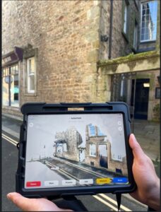
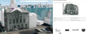
- Enhancing 3D visualisation – transformed an existing 2D visualisation app into a more immersive 3D experience, that incorporated multiple data sources, dramatically improving comprehension and accessibility of planning information with Garsdale Design.
- Gaming technology – customised a gaming platform specifically for Lancaster, enabling children to design and visualise their ideal local environment, including new schools and green spaces.
- Designed physical resources – created a card deck, which is available open source (just need an email address to receive them) for any local authority to use, to facilitate engagement walks and structured thinking about placemaking.
- Tangible 3D model – produced a portable 3D printed model of the area at planning scale for use as an interactive focal point during workshops, with the capability to project different data overlays.
- Involved the public in using LiDAR technology (laser scanning equipment) to map the area in public data walks – creating an up-to-date detailed 3D digital map of local streets and public spaces.
Results
This project demonstrates how digital innovation can transform heritage and conservation engagement from a traditional planning perspective to an inclusive,
The project delivered a series of measurable outcomes:
- Enhanced professional capabilities – following training, 100% of planning officers reported feeling confident using the 3D model – a 40% increase – with 25% now using it daily in their work.
- Strong digital engagement – the 3D app averaged 298 daily views during the first 10 weeks, while the interactive Storymap, documenting the project journey, received 344 views during the period.
- Innovative public participation – the project successfully integrated heritage tours with technology, with members of the public collecting valuable lidar data that council staff could use later.
Overall, this approach has created a sustainable foundation for future heritage-led regeneration projects while enhancing planning officers’ skills using 3D models and geographic information systems (GIS).
Jonathan Noad, Chief Officer Sustainable Growth, Lancaster City Council, said: “By improving understanding of the heritage significance of the area we can support high-quality and sympathetic future development and help aid better decision-making.”
Paul Cureton, Senior Lecturer in Design Imagination Lancaster, said: “So few engage in how our spaces are being transformed, so there is space for gaming in this field to provide and help the public think like planners, play issues and use gaming tools for modelling future spaces.”
Next steps
The tools developed can be adapted by any local authority. The approach is being considered for use in to develop the council’s local plan, potentially addressing engagement with young people and other underrepresented groups in planning.
For more information watch the detailed video created by the project teams, which showcases their innovative approach and results.
For more information
If you’re a Local Planning Authority looking to modernise planning processes and enhance digital skills and capabilities, explore joining the Open Digital Planning community to gain access to resources, peer support, and digital expertise.