 UK Ministry of Housing, Communities and Local Government (MHCLG)
 Back to Digital Planning Programme Case Studies
Summary
Plymouth City Council, South Hams District Council and West Devon Borough Councils were considering the best approach for updating their Joint Local Plan (JLP). The JLP authorities undertook an innovative pilot to explore how PropTech tools could enhance the efficiency of call for sites processes and baseline evidence collection to inform a future Local Plan. Working with three specialist suppliers, the project addressed key challenges regarding data accessibility, call for sites consultations and site suitability assessment. The initiative demonstrated significant potential for time savings, improved officer capabilities, and more responsive evidence gathering.
The pilot demonstrated the potential for a range of improvements to site assessment processes through the use of digital technology. These include the potential to overhaul traditional call for sites submission process with self-service functionality and estimated savings of more than 50% for every site received and assessed as the result of a call for sites exercise.
Challenge
The JLP authorities faced several interconnected challenges with their plan-making process. A critical skills gap existed around Geographic Information System (GIS) capabilities, with planning officers heavily dependent on a small number of specialist GIS staff for data visualisation and mapping tasks. This created bottlenecks and limited officers’ ability to work independently with spatial data.
The traditional call for sites process was resource-intensive, requiring GIS officers to manually digitise hundreds of site submissions from PDF documents before any assessment and reporting could begin. Much of this work was then wasted when sites were later deemed ‘unsuitable’ for development within the first phases of site assessment as a part of the Strategic Housing Land Availability Assessment (SHLAA).
Officers also identified the challenges of maintaining an up to date evidence post Local Plan adoption, as evidence prepared for the Local Plan often relies on point-in-time consultant reports rather than live data. The SHLAA process was identified as particularly cumbersome, with site assessments requiring officers to navigate multiple disparate systems and websites hosting point in time data to gather the information needed to maintain robust evidence up to plan examination by the Planning Inspectorate.
Approach
Following detailed engagement with planning, GIS and data specialists through workshops and interviews, the authorities developed a comprehensive three-strand approach. Each work strand targeted specific workflow inefficiencies while building towards a more integrated digital planning approach.
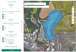
- The first work strand focused on improving the visibility of open and Public Sector Geospatial Agreement building and land use data to support planning evidence, partnering with City Science to develop a minimum viable product data library. This focused on making up-to-date geospatial datasets more accessible to planning officers without requiring specialist GIS training, addressing the skills gap whilst reducing dependence on limited GIS resources.
- The second strand trialled Commonplace’s mapping features to streamline the call for sites process. Rather than submitting PDFs for manual digitisation, the platform enabled developers and agents to directly input geospatial data, saving hours of officer time per consultation round.
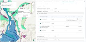
- The third strand explored trialling Urban Intelligence’s PlaceMaker product in a like for like test of site suitability assessment using past SHLAA submissions data. This specialist tool was designed to enable planning officers to undertake SHLAA processes independently, incorporating constraints mapping, land ownership data, and automated development density calculations within a single platform.
Throughout the project, collaborative working practices ensured continuous feedback and iterative improvement. Regular delivery meetings, user testing sessions, and cross-departmental engagement helped refine the tools to meet local needs whilst building officer confidence and capabilities.
Results
- The pilot delivered measurable improvements across all three work strands with the tools saving over 50% of officer time on identified call for sites and evidence tasks.
- Officers have gained instant access to over 40 datasets through an easy to use GIS applications and data library designed for planners, enabling more responsive and dynamic evidence gathering throughout the Local Plan process.
- Through the use of more accessible software and data availability, the number of officers capable of potentially using GIS in their work was tripled, reducing the exposure to single points of failure and delivery bottlenecks within planning evidence work.
- Reduced reliance on outdated consultant reports and provided officers with up-to-date information to support their decision-making.
- The specialist site assessment tool transformed overall approaches to identifying development opportunities, enabling Plymouth City Council to now be taking proactive engagement with landowners to identify future development opportunities.
- Officer confidence in using GIS tools independently increased and surveyed officers felt the new software would improve their future work, indicating strong buy-in for continued digital transformation.
The project highlighted important considerations for other authorities, particularly around data quality dependencies and the iterative nature of embedding digital tools into established working practices. While the results show clear potential for transformation, they also emphasise the importance of ongoing training programmes and gradual culture change to maximise the benefits of PropTech innovation into evolving planning practice.
Alistair Wagstaff, Strategic Planning Manager, Plymouth City Council, said: “It is clear from our work in the PropTech Innovation Fund pilot that modern software designed to meet planners’ needs will enable us to rethink the way we approach our evidence work and support us to achieve high quality outcomes through a new local plan.”
Phil Baker, Head of Strategic Planning for South Hams District Council and West Devon Borough Council, said: “The PropTech Innovation Fund has been critical in informing our future approach to site assessment to help inform a future Local Plan, the partnership work done to date shows the massive potential of PropTech to support us in this important area of our work.”
For more information
If you’re a Local Planning Authority looking to modernise planning processes and enhance digital skills and capabilities, explore joining the Open Digital Planning community to gain access to resources, peer support, and digital expertise.