 UK Ministry of Housing, Communities and Local Government (MHCLG)
 Back to Digital Planning Programme Case Studies
Summary
As part of preparing a Local Plan, a local planning authority needs to identify, evaluate and select suitable sites for development and future growth. This is based on suitability, deliverability, infrastructure and environmental considerations, alignment with planning policy and community feedback. South Cambridgeshire District Council and Cambridge City Council successfully implemented an innovative PropTech solution to revolutionise their site assessment and allocation process for the councils’ emerging joint Greater Cambridge Local Plan. By utilising four specialist suppliers and their technologies — site assessment platforms, 3D modelling tools, and consultation systems — the councils created a standardised, efficient, and transparent approach to assessing and allocating sites.
Challenge
The councils, which share the Greater Cambridge Shared Planning Service, faced significant challenges in their traditional manual site assessment processes, as they were time-consuming, resource-intensive, and lacked transparency for public engagement. Manual data handling was consuming excessive staff time, with a number of officers spending weeks on individual site assessments and scenario testing. This means planners were using their valuable experience on more administrative processes rather than where it is perhaps better utilised in supporting local people and communities. The councils needed solutions that could deliver significant time savings and increase efficiency, whilst improving assessment quality and consistency. The shared planning service also wanted to get more people actively involved in the planning process.
Approach
The project, funded by the PropTech Innovation Fund, was delivered through a four-stage implementation process, bringing together specialist suppliers with complementary expertise.
- TPX Impact conducted comprehensive data discovery to map existing processes and identify integration opportunities.
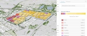
- Urban Intelligence configured their Placemaker software to create a robust site assessment platform that could consolidate and analyse data efficiently. This was set up to maintain a consistency with the council’s already established assessment methodology and create a cross departmental and stakeholder online platform to streamline the assessment process.
- Esri’s ArcGIS Urban tools were deployed for detailed 3D scenario modelling, transforming months of manual capacity testing into streamlined digital workflows.
- Finally, JDi Solutions enhanced their existing consultation platform to incorporate 3D capabilities for more interactive public assessments.
By using the specialist tools and functionalities of the different technologies, the councils have been able to make significant time and resource savings. This multi-vendor approach shows that both new and legacy systems can complement each other to speed up plan making.
Results
The project has delivered transformative outcomes that extend far beyond the original objectives.
- Successfully procured and implemented ESRI and Urban Intelligence software, with infrastructure metrics integrated into the 3D modelling environment.
- Developed three test sites in Cambridge with enhanced metrics capabilities, enabling rapid scenario testing.
- Reduced manual data handling by officers by over 50%, whilst cutting site capacity testing time from months to just 1-2 weeks for large developments. This time saving has freed up officer capacity to focus on strategic planning challenges whilst maintaining higher quality and more consistent assessments.
- The cloud-based solution revolutionised collaboration between site assessors across different service areas and organisations.
- The standardised approach has improved consistency and robustness for site selection in plan-making, whilst 3D visualisations have enhanced transparency and understanding, supporting future public engagement.
Heather Jones, Deputy Director of Planning, said: “For too long, councils have been limited and stuck with a fragmented approach, manually piecing together data and evidence over a wide range of disconnected technologies and systems. This initiative has enabled us to demonstrate that by bringing vendors together, a cohesive and effective digital ecosystem to aid delivery of the Local Plan is possible. We’ve proven that companies are not only willing but eager to collaborate, and this is fundamentally improving how we manage our Local Plan process, driving accessibility and understanding, making it more engaging and visual for the wider community. It’s a true step forward for digital collaboration in the public sector.”
The project has established a foundation for continued innovation, with plans to expand 3D modelling capabilities for community consultations and explore additional metrics integration. The creation of a Local Plan site assessment database in Placemaker and the potential for further Esri Urban development demonstrate the lasting impact of this PropTech initiative.
For more information
If you’re a Local Planning Authority looking to modernise planning processes and enhance digital skills and capabilities, explore joining the Open Digital Planning community to gain access to resources, peer support, and digital expertise.