 UK Ministry of Housing, Communities and Local Government (MHCLG)
 Back to Digital Planning Programme Case Studies
Summary
East Hertfordshire District Council revolutionised their Call for Sites consultation process through digital innovation, addressing the challenge of labour-intensive manual processes that consumed significant officer time.
Using PropTech Innovation funding, they partnered with Cadcorp Limited to develop an integrated online portal featuring Geographic Information Systems (GIS) mapping, automated constraint identification, and streamlined data collection. The solution delivered remarkable results, with (compared to none previously), processing time reduced by over 60%, and substantial cost savings per site. The tool successfully managed complex submissions whilst improving accessibility for diverse community stakeholders including residents and community groups.
Challenge
East Hertfordshire District Council encountered operational difficulties with their traditional Call for Sites consultation approach. The manual process of plotting and recording planning constraints against submitted sites required extensive officer time, as experienced during their previous Local Plan development in 2016.
Staff faced labour-intensive data collection procedures, time-consuming spatial analysis requirements, and challenges standardising the information which was received in several different formats. These inefficiencies not only strained resources but also limited effective engagement with landowners, developers, and the broader community, potentially restricting participation in this crucial planning process.
Approach
The comprehensive digital platform transformed every aspect of the council’s Call for Sites consultation.
By building upon their existing IT and GIS contract with the supplier, the council was able to add the new services seamlessly, significantly reducing procurement delays and accelerating project delivery.
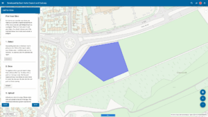
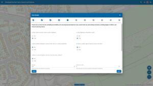
They developed a publicly accessible web portal which collected information in a standardised form and stored it securely in a database for analysis. The platform was integrated with existing GIS technology and data, enabling users to submit sites through multiple methods including polygon selection from OS MasterMap, manual drawing tools, or spatial file uploads.
The platform automatically identified and incorporated constraints by reading the GIS data to provide immediate information about planning issues and restrictions. Publishing capabilities meant that a consultation summary with embedded maps could be produced with individual site summary cards.
Results
The digital transformation delivered exceptional outcomes across many areas.
- Achieved 100% digital processing of approximately 290 consultation responses, with 95.9% submitted directly through the online portal and only 12 requiring staff assistance.
- Delivered over 60% reduction in processing time per site through automation of key tasks including site identification, GIS plotting, and data gathering, generating significant cost savings in staff resources.
- Enhanced accessibility and transparency, attracting participation from a broader cross-section of the community including residents and community groups alongside traditional agents and developers.
- Maintained high data quality through standardised formats whilst effectively managing increasingly complex submissions and smaller sites. Three spurious submissions were easily identified and filtered digitally, demonstrating improved quality control capabilities over manual processes.
- The council will now continue to use the tool for future call for sites consultations, with its customisable design offering potential for adaptation by other local planning authorities seeking similar efficiency gains and enhanced public engagement.
Claire Sime, Service Manager, Planning Policy, Design and Conservation, said: “Developing this tool with Cadcorp Ltd has helped us to automate processes and save valuable time, allowing us to focus on analysing the responses from our Call for Sites consultation. We now hold digital data on submitted sites that integrates with other spatial information, such as site constraints and proximity to areas of growth. These outputs make our site assessments more efficient and will pave the way for easier evidence-based assessment of the sites.”
For more information
If you’re a Local Planning Authority looking to modernise planning processes and enhance digital skills and capabilities, explore joining the Open Digital Planning community to gain access to resources, peer support, and digital expertise.