 UK Ministry of Housing, Communities and Local Government (MHCLG)
 Back to Digital Planning Programme Case Studies
Summary
Central Lincolnshire is a combined area covered by the City of Lincoln, North Kesteven and West Lindsey. These three councils have come together with Lincolnshire County Council to prepare a joint Local Plan for the area.
The Central Lincolnshire Local Plans team used ArcGIS to create an integrated mapping, planning and engagement platform. The project transformed fragmented working practices across the authorities by introducing digital tools, streamlining plan-making processes and dramatically enhancing public consultation responses.
Previously tools and processes for plan-making existed in separate software systems, creating inefficient working practices and a disjointed user-experience. Each authority operated different systems, making collaboration challenging and leading to inconsistent approaches and issues sharing data across the area.
Challenge
The Central Lincolnshire Local Plans team faced challenges working with disconnected systems across the councils, that created inefficient working practices and poor user experience. Different processes made collaboration difficult and resulted in inconsistent engagement approaches.
Traditional plan-making consultations typically received between 200-400 responses, heavily skewed towards development industry professionals (25-35% of responses), with statutory consultees and council officials making up another 25%. Genuine resident engagement was limited, with fewer than 100 residents typically responding to early-stage consultations. The partnership struggled to engage younger residents and diverse ethnic groups, with responses predominantly coming from older, white British demographics.
The large and diverse geography of Central Lincolnshire compounded these challenges, making it difficult to achieve consistent engagement across both urban and rural communities.
Approach
The teams used a framework to evaluate suppliers, selecting Esri’s ArcGIS platform as the best fit for their objectives. A further four-month procurement process then followed involving detailed discussions with the supplier to ensure thorough understanding of the platform’s capabilities, goal alignment, and licencing options.
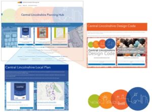
The team created a new planning hub hosting Local Plan information and policies maps in a more accessible format. They developed pages to improve public understanding of design codes and hosted three surveys including a map-based consultation to trial the ArcGIS functionality and created StoryMaps to present the findings.
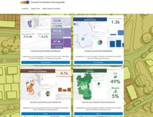
They produced data sheets to present information about the area to boost transparency and use the data to inform changes to their engagement strategy.
Over 20 officers across the three councils underwent training to use the platform and learn how to develop projects within the system. While officers were initially unfamiliar with the platform’s functions and it required significant time investment to develop their skills, the platform has generated substantial interest among staff.
Planning officers have also forged closer working relationships with economic development, communications, information and strategy teams across the partnership. Conversations are taking place about expanding use of the tool and collaborating further.
The project timeline had to be extended due to resource constraints and the complexity of coordinating training across the different organisations, but this also provided an opportunity for more thorough system development and stakeholder preparation.
Results
The transformation in public engagement and enhanced partnership working is very clear:
- The first consultation using ArcGIS, on the high-level principles for a new design code, to help inform its scope, received 462 responses from 359 respondents – a substantial increase from typical consultation response rates in early-stage planning consultations. Most significantly 85% of responses came from individual residents compared to fewer than 100 residents in previous comparable early-stage consultations.
- Established effective partnership working across the three councils, with officers now collaborating on State of District reports, council land analysis projects, and various corporate initiatives.
- Formed new academic partnerships with the University of Lincoln, creating opportunities for student placements and curriculum development.
- Generated excellent response from colleagues and partner organisations, with many ArcGIS-using organisations expressing interest in streamlined collaboration and data sharing.
- The partnership continues developing business cases to embed the platform for other uses, focusing on delivering enhanced efficiency, improved engagement, and collaborative working that extends beyond traditional planning functions.
- Whilst challenges remain in reaching younger demographics and diverse ethnic groups, the project has established a strong foundation for continued digital transformation and community engagement improvements.
- The absence of a qualified GIS officer proved a key challenge making both procurement and project delivery more complex and requiring significantly more input from planning officers and other team members than anticipated.
Philip Hylton, Local Plans Manager, Central Lincolnshire Local Plans Team, said: “PropTech has enabled the Central Lincolnshire partnership to take significant strides towards proper digitisation of our plan-making services. Our early work has started to identify the power of the ArcGIS tools available and the substantial benefits they will bring to how we work and to the communities we serve. We will continue to develop our practices to drive efficiency, transparency and effectiveness in our work.”
For more information
- If you’re a Local Planning Authority looking to modernise planning processes and enhance digital skills and capabilities, join the Open Digital Planning community to gain access to resources, peer support, and digital expertise.